Nyarugenge District
Nyarugenge District | |
|---|---|
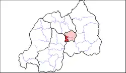 Shown within Kigali Province and Rwanda | |
| Country | Rwanda |
| Province | Kigali |
| Capital | Nyarugenge |
| Area | |
• Total | 134 km2 (52 sq mi) |
| Population (2022 census) | |
• Total | 374,319 |
| • Density | 2,800/km2 (7,200/sq mi) |

Nyarugenge is a district (akarere) in Kigali Province, Rwanda. Its heart is the city centre of Kigali (which is towards the west of the urban area and the province), and contains most of the city's businesses.
Sectors
Nyarugenge district is divided into 10 sectors (imirenge): Gitega, Kanyinya, Kigali, Kimisagara, Mageragere, Muhima, Nyakabanda, Nyamirambo, Nyarugenge and Rwezamenyo.
Population
| Historical Population of the Nyarugenge District | ||
|---|---|---|
| Year | Population Nyarugenge |
Census of Population and Housing[1][2] |
| 2002 |  236,990 236,990
|
2002 Rwandan Census |
| 2012 |  284,561 284,561
|
2012 Rwandan Census |
| 2022 | 374,319
|
2022 Rwandan Census |
| Sectors of the Nyarugenge District by population according to the 2022 census | ||
|---|---|---|
| N° | Sectors of District Nyarugenge |
Census (2022)[2] |
| 1° | Kigali | 61,499 |
| 2° | Mageregere | 59,747 |
| 3° | Kimisagara | 56,534 |
| 4° | Nyamirambo | 55,315 |
| 5° | Kanyinya | 31,026 |
| 6° | Nyakabanda | 29,580 |
| 7° | Gitega | 26,668 |
| 8° | Muhima | 22,531 |
| 9° | Nyarugenge | 16,665 |
| 10° | Rwezamenyo | 14,754 |
| Total | Nyarugenge District | 374,319 |
Education
Lycée de Kigali (LDK) is in Kiyovu Cell, Nyarugenge Sector, Nyarugenge District.[3]
References
- ^ "Population of Rwanda according to the population and housing censuses". citypopulation.de. 2022-08-01. Retrieved 2023-03-05.
- ^ a b National Institute of Statistics of Rwanda (2023-02-28). "5th Population and Housing Census : Main Indicators Report". statistics.gov.rw. Retrieved 2023-03-05.
- ^ "Introduction Archived 2012-09-23 at the Wayback Machine." (Archive) Lycée de Kigali. Retrieved on 3 March 2013.
External links
- "Districts of Rwanda". Statoids.
- Inzego.doc — Province, District and Sector information from MINALOC, the Rwanda ministry of local government.